History of the Celtic tribes
The Atrebates
The Atrebates share their name with a tribe in pre-Roman Gaul (France). Their territory in Britain originally stretched from what is now present day West Sussex, Hampshire and Berkshire.
At the time of the Roman Conquest, the Atrebates were the second most powerful tribe in southern Britain, it was an appeal for help from their king, Verica, which provided the Emperor Claudius with the pretext to launch his invasion on Britain in 43 AD.
Buster hill iron age farm
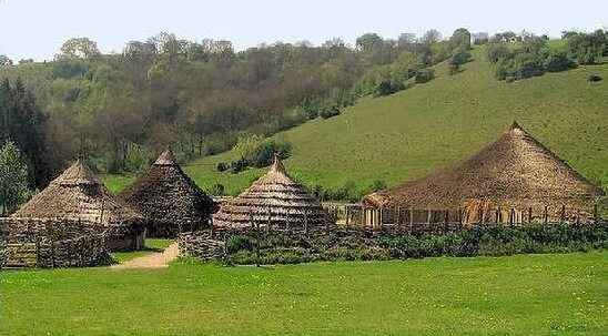
Following the Roman Conquest, the territory of the Atrebates was divided into three separate civitates, one of these was centred at the settlement at Silchester, near Reading. Another major centre, comparable to those at St Albans, Colchester and Stanwick, was at Chichester.
Butser Ancient Farm, an experimental archaeological site in South Downs National Park, Hampshire, displays ongoing constructions of Iron Age buildings based on real sites, crops from prehistory and rare breeds of animals, providing a glimpse at the life of the Atrebates during the Iron Age.
The Belgae
The Belgae were a group of Gallo-Germanic tribes living in northern Gaul, between the English Channel and the west bank of the River Rhine, from at least the 3rd century BC. They sailed across the English Channel into southern Britain in the time of Julius Caesar. Caesar asserted they had first crossed the channel as raiders, only later establishing themselves in Britain. The Belgae was bordered to the North by the British Atrebates, and to the east by the Regnenses, who was possibly also linked to the Belgae. According to the Roman geographer, Ptolemy the territory of the Belgae included not only Winchester but also Bath nearby and a settlement called Ischalis which as yet remains unidentified.
The Brigantes
The warlike Brigantes occupied the largest section of what would later become Northern England and a significant part of the Midlands. Their name derives from the Celtic goddess Brigantia. Territorially the largest tribe in Britain, their kingdom, centred in what later became Yorkshire, is referred to as Brigantia.
At the time of the Roman invasion in 43 AD, the Brigantes were amongst the most powerful Celtic tribes in Britain. There remains much evidence of Iron Age settlement in Cumbria, with hill forts, such as those at Castle Crag in Borrowdale and Dunmallard Hill, near Pooley Bridge, Ullswater. The remains at Dunmallard Hill consist of a deep ditch and ramparts. The small fort covers about 1.5 acres and contains the remains of dwellings.
Following the Roman conquest of England in 43 AD, Cumbria remained independent of Roman rule for some time. The Romans marched their armies into Cumbria under Julius Agricola in 79 A.D., and subjugated the native Celtic Brigantes tribes, conquering the whole of the territory. Establishing a fort at Watercrook, near Kendal, they built a road to the naval base at Ravenglass, over the high fells of Wrynose and Hardknott passes. Cohort forts were built along the road to control and dominate the area and strengthen lines of communication. The vast Hard Knott Roman Fort, or Mediobocdum as it was known to the Romans, stands on a bleak plateau, commanding a strategic position below Hard Knott Pass covering three acres.
Under the leadership of their queen, Cartimandua, the Brigantes came to be on cordial terms with the Romans, acting as a "client-kingdom" of the Empire. Cartimandua betrayed Caratacus, ruler of the Catuvellauni tribe to the Romans, thereby depriving Celtic Britain of its most determined resistance leader.
Cartimandua and her husband Venutius later divorced, Venutius took up arms first against his ex-wife, then her Roman protectors. During the governorship of Aulus Didius Gallus (52-57), he gathered an army and invaded her kingdom. The Romans sent troops to defend Cartimandua, and put down rebellion. After her divorce, Cartimandua married Venutius' armour-bearer, Vellocatus, and raised him to the kingship. Venutius staged another rebellion in 69, taking advantage of Roman instability in the Year of four emperors. This time the Romans were only able to send auxiliaries, who succeeded in evacuating Cartimandua but left Venutius and his anti-Roman supporters in control of the kingdom.
Following the departure of the Romans from Britain, the territory of the Brigantes was later incorporated into the Celtic kingdom of Rheged which survived until the early eigth century.
Celtic Tribe of England and Wales
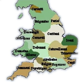
The Cantii
The Cantii or people of the corner land, lived in what is today modern Kent, along with the eastern parts of Surrey, East Sussex and Greater London, the county of Kent still retains the name of the tribe. Their capital was Durovernum Cantiacorum, now known as Canterbury.
In common with many of their neighbours in the southeast of England at the time, the Cantii were a Belgic people from the North Sea or Baltics, part of the third wave of Celtic settlers in Britain. They were the first tribe in Britain to issue their own coinage. Julius Caesar recorded of the Cantii:- "Of all these (British tribes), by far the most civilised are they who dwell in Kent, which is entirely a maritime region, and who differ but little from the Gauls in their customs".
Archaeological finds in the territory of the Cantii include the Battersea shield, so named as it was accidentally dredged from the Thames at Battersea in 1857, the shield is now in the British Museum. Though made of bronze it dates not from the Bronze Age but from the late Iron Age, close to the end of the first century B.C. or early in the first century A.D., just before the Roman conquest of Britain. There are a few other examples of weapons recovered from rivers, a shield was found in the River Witham near Lincoln and parts of a shield were discovered in the Thames at Wandsworth and a Celtic helmet, known as the Waterloo helmet was dredged from the Thames in 1868. All three of these were discovered in rivers. It would seem highly implausible that shields and other such items would have been lost accidentally. It is likely that the Celt's treasured weapons were thrown in as an offering, gift or sacrifice, to appease the river god.
The Carvetii
The Carvetii inhabited the area which is now Cumbria, parts of north Lancashire, south-west Durham in northern England and south-east Dumfries & Galloway in Scotland. Their capital is presumed to have been Luguvalium (Carlisle). The tribe are omitted from the work of Ptolemy, the major historical source of the names of indigenous tribes, which meant the Carvetii went unidentified until an inscribed Roman tombstone was found in 1600 at Penrith. The stone recorded that Flavius Martius was ... sen(ator) in C(ivitas) carvetior(um) ..., 'a senator on the tribal council of the Carvetii'.
The Catuvellauni
The Catuvellauni were probably the most powerful Belgic tribe in Iron Age Britain and occupied the area to the north of the River Thames, the modern counties of Hertfordshire, Cambridgeshire, Northamptonshire, Bedfordshire, Buckinghamshire and Oxfordshire east of the River Cherwell. Their name is said to derive from two words: 'cat', meaning battle, and 'vel', which is thought to mean 'leader', therefore 'the battle leader'.
The first capital of the Catuvellauni was located near Wheathampstead, they opposed Julius Caesar under their chief Cassivellaunus, but after their defeat by Caesar in 54 BC, they expanded to the north and northwest, building a new capital at Verulamium (St. Albans). The Catuvellauni were farmers and apparently had a prosperous economy.
When Emperor Claudius launched his invasion of Britain in the summer of 43 AD, they rose in revolt under their leader Caractacus, son of the Celtic king, Cunobelinus, Caractacus adopted guerrilla tactics to resist the Roman general Aulus Plautius. He and his brother Togodumnus lost much of the south-east after being defeated in two crucial battles on the rivers Medway and Thames. Some tribes, realising that the end was near, made peace with the invaders, but Caractacus and the Catuvellauni fought on. After Togodumnus was slain and resistance to the Romans collapsed in the South-East of England, Caractacus established himself with the Dubonni tribe, He then went on to lead the Silures and Ordovices of Wales against Plautius' successor as governor, Publius Ostorius Scapula.
The Corieltavi
The Coritani or Corieltavi occupied the eastern midlands, in the counties of Lincolnshire, Leicestershire, Nottinghamshire, Derbyshire, Rutland and Northamptonshire. They were bordered by the Brigantes to the North, the Cornovii to the West, the Dobunni and Catuvellauni to the South, and the Iceni to the East.
The tribe issued coins before the Roman invasion. Their capital was at Ratae Corieltauvorum, (Leicester) Ptolemy mentions their town of Lindum (Lincoln) which was abandoned as a legionary base in the late '70s and its legion moved to Deva (Chester).
The Cornovii
The Cornovii is the name by which two, or possibly three tribes were known to the Romans. One tribe was in the area consisting of modern Shropshire, Cheshire and the Wirral, north Staffordshire, north Herefordshire and eastern parts of Powys. Another was in Caithness in northern Scotland, and in addition, there was probably one in Cornwall.
Ptolemy's 2nd-century Geography names two of the towns of the midlands Cornovii, Deva Victrix (Chester), and Viroconium Cornoviorum (Wroxeter) was their capital and probably the fourth largest Roman settlement in Britain. Prior to the Roman invasion of Cornovian territory in 47 AD the most significant Cornovian hillforts known were those at Titterstone Clee near Bitterley, Chesterton Walls near Romsley and Bury Walls near Weston-under-Redcastle. Other hillforts of Iron Age Cornovii include the Wrekin hillfort near Wellington, Caynham Camp near Poughnhill and Old Oswestry. There was a further significant settlement at the Breiddin hillfort in Powys.
Holyhead mountain hut
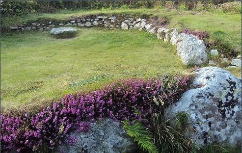
The Deceangli were the peoples of what is today north Wales and probably included the peoples who lived on the Isle of Mona or Anglesey. Significant remains of the Iron Age settlement at the foot of Holyhead Mountain survive to the present, also known as Cytiau'r Gwyddelod, which translates as 'The Irishmen's Huts', other names used for the settlement include Clwster Cytiau Mynydd Caergybi and the Ty Mawr Hut Group. 20 out of the original 50 Iron Age buildings survive, once a large farming community covering 15-20 acres, that originated in around 500 B.C.
The remains of the huts are scattered along the hillside, as well as numerous smaller partly subterranean storage sheds, cattle shelters and workshops, similar to those found in early Cornish villages. Evidence of metalworking was found in some of these buildings. The round stone huts measure around 7 metres in diameter with thick, low walls. They would have had a high, conical roof supported on a ring of posts and thatched with straw or reeds. Inside some of the hut circles, there are examples of stone furniture including ledges and basins incorporated into the stonework.
There is evidence of a long history of settlement from the Middle Stone Age, Neolithic and Bronze Age, to the Iron Age. At the east end of the site, there is another group of huts. The surrounding land was ploughed by the community, wheat, oats and barley seeds have been discovered, evidence of limpet and periwinkle shells offer a clear indication that food was also taken from the sea. Charcoal of heather and sedge was also discovered. A small hoard of Roman coins was also found within one of the huts. The Roman finds lead to the belief that the hut group was a Romano-British settlement but more recent radiocarbon dating suggests some of the settlement was occupied as early as 500BC.
Anglesey, or Mona as it was then known, was a stronghold of the Druids. The Druids encouraged the Celtic Britons to resist the Roman conquest, and accordingly were specifically targeted by the Romans for destruction. On the eve of the revolt of Boudicca and the Iceni in what is today East Anglia, the Roman Army has only just completed the long and difficult task of conquering the tribes living in the Welsh Mountains. The druids made a last stand on Anglesey where they were then slaughtered.
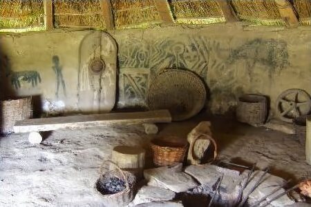
Iron age roundhouse
The Demetae
The Demetae inhabited modern Pembrokeshire and Carmarthenshire in south-west Wales and gave their name to the county of Dyfed. Their origin is uncertain, however, a number of the place names of the Demetae are similar to what were Celtic regions in what is now the Bordeaux region of France as Llanmadoc and Landes du Médoc, Gwynedd and Gironde, Demetae and Devèze.
They are mentioned in Ptolemy's Geographia, as being west of the Silures. He refers to two of their towns, Moridunum (Carmarthen) and Luentinum (identified as the Dolaucothi Gold Mines near Pumsaint, Carmarthenshire). They are not mentioned in Tacitus' accounts of Roman warfare in Wales, which concentrate on their neighbours the Silures and Ordovices.
Castell Henllys near Eglwsywrw in Pembrokeshire has a reconstructed Iron Age hill fort. The promontory fort has been extensively excavated, the reconstructed roundhouses can be seen in the interior of the fort.
The Dumnonii
The Dumnonii inhabited the area which is now known as Cornwall (Cornubia), Devon (Dyfneint- meaning 'deep valley dwellers') and Somerset (the 'Summer Land' of the Mabinogion). Their name probably means 'the masters', or 'the dominators' and derives from a Gaulish word which is cognate with the Latin 'dominus'.
In the eastern half of their territory, the part of Devon which lay to the west of the River Exe, they appear to have used hill forts of the common British type, but across the Tamar, into modern Cornwall, these virtually disappear and their place is taken by fortifications which are very similar to those in Brittany and Spain. Their original capital was Keresk ('Caer Uisc'), or modern Exeter, which the Romans referred to as Isca Dumnoniorum.
Evidence exists that the Dumnonii had links with Brittany, with whom they shared similar styles of highly decorated pottery. The Dumnonii became civilised due to foreign interest in tin mines and were notably friendly to strangers. By 43 AD, they were successfully mining tin and other minerals from Dartmoor, the Tamar Valley, and Cornwall, and were trading tin with early Mediterranean civilisations, including probably the Phoenicians, from the ancient port of Ictis (St. Michael's Mount, Cornwall).
The Dumnonii seem to have accepted the Roman conquest without resistance and as a result, few garrison forts were placed in their territory, although this area never fully adopted Roman ways of life. Lifestyles and types of settlements remained little changed from the Iron Age through the Roman period. The Celtic Kingdom of Dumnonia survived up until the eighth century.
Inhabited from around 100B.C to the third century A.D. Chysauster Iron Age Village, near Penzance, in the Penwith District of southwest Cornwall, was probably built by members of the ancient Celtic Dumnonii tribe. The village has nine courtyard houses, with a further house lying just beyond. All similar in layout, a passage leads from the house entrances to an inner courtyard. Each dwelling has a main chamber with further chambers progressing from it. The roofs were probably composed of thatch and there is some evidence that they once possessed drains.
The Durotriges
The Durotriges tribe occupied modern Dorset, south Wiltshire, south Somerset and Devon east of the River Axe. Following the Roman conquest, their main civitates, or settlement-centred administrative units, were Durnovaria (modern Dorchester) and Lindinis (modern Ilchester). Their territory was bordered to the west by the Dumnonii, and to the east by the Belgae. The Durotriges were more a tribal confederation than a tribe. They were one of the groups that issued a simple coinage before the Roman conquest. During their conquest of Britain in 43 AD and Vespasian's campaign to conquer the tribes of the Atrebates, Dumnonii, and Durotriges in the southwest of Britain which took place in AD 43-47, the Romans attacked the Durotriges at the vast Maiden Castle hillfort in Dorset and a fierce battle ensued by its eastern entrance. When mass graves were excavated at Maiden Castle near Dorchester during the 1930s, a skeleton with a Roman ballista bolt lodged in its spine was unearthed.
The Iceni
The fierce Iceni tribe inhabited an area corresponding roughly to the modern-day county of Norfolk. They rose in revolt against Roman rule under their queen Boudicca in 60 or 61 A.D., burning Camulodunum (Colchester), Londinium (London) and Verulamium (St.Albans) to the ground before being defeated in battle in the Midlands by the Roman Gaius Suetonius Paulinus.
The Iceni had important religious centres at Snettisham and at Thetford. The finest hoards of gold treasure found in Iron Age Britain, the Snettisham torcs, were unearthed in the territory of the Iceni. The Snettisham Hoard was unearthed in Norfolk between 1948 and 1973. The hoard consists of metal, jet and over 150 gold torc fragments, over 70 of which form complete torcs, dating from BC 70.
Though the hoards origin is unknown, it is of sufficiently high quality to have been a royal treasure of the Iceni. The Roman historian Dio Cassius described Boudica wearing a magnificent gold neck ring. This was almost certainly a torc. Other hoards of elaborately decorated bronze chariot fittings indicate a love of conspicuous display by the nobles of the Iceni.
Cockley Cley, 3 miles South West of Swaffham, in Norfolk, has a reconstruction of an Iceni Village, which recreates the life of the Iceni in Britain just before the invasion of the Romans around 2000 years ago.
The Ordovices
The Ordovices inhabited south Gwynedd and south Clwyd, including parts of western Shropshire and Hereford & Worcester. They were bordered to the north-east by the Deceangi, to the east by the Cornovii, on the south-east by the Silures and to the south-west by the Demetae. The Celtic name ordo-wik- could have a meaning in some way related to the word for "hammer"; Irish 'Ord', Welsh 'Gordd' and Breton 'Horzh', all of which mean "hammer". Their name is preserved in the place name Dinorwig ("Fort of the Ordovices") in North Wales.
The Ordovices resisted the Romans, led by the Celtic leader Caratacus, exiled in their lands after the defeat of his tribe in the Battle of the Medway. Following the Battle of Caer Caradoc, where governor Publius Ostorius Scapula defeated Caratacus, the Ordovices were no longer a threat to Rome, probably due to the heavy losses they had experienced. In the '70s, the Ordovices rose in rebellion against Roman occupation and destroyed a cavalry squadron. This act of war provoked an equally strong response from Agricola, who, according to Tacitus, exterminated the whole tribe. No other mention of the tribe appears in the historical records, but considering the mountainous terrain of the lands of the Ordovices, it is questionable whether Agricola could have wiped out the entire population.
The Parisi
The Parisi occupied the area roughly equivalent to modern East Yorkshire and farmed the chalk hills of the Yorkshire Wolds. They were surrounded to the north, west and south-west by the Brigantes and on the south by the Coritani. Their name possibly derived from the proto-Celtic 'kwarjo', the 'kw' became 'p', so 'Parjo', or people of the kettle. Their capital was at Brough.
They share their name with the people who lived in France around modern Paris although whether both tribes shared strong links remains a matter of debate. The British Parisi are known for their unusual funerary traditions chariot-burials, with swords and spearheads, pigs and horses, and burial within square enclosures, appear to link their "Arras culture" to the La Tène culture in Europe. Finds from their chariot burials are housed in the Yorkshire Museum at York.
The Regneses
The Regnenses tribe occupied East Sussex, West Sussex and parts of Surrey and Hampshire. They were an amalgamation of Belgic peoples gathered together under the client king Cogidubnus by the Romans. The Kingdom did not exist prior to Roman rule. Their capital was Noviomagus Reginorum, known today as Chichester in modern West Sussex. After the future Emperor Vespasian had subdued the southwest of England, Cogidubnus, chief of the Regneses tribe, was set up to rule several territories as a vassal king of Rome.
The Silures
Hill fort
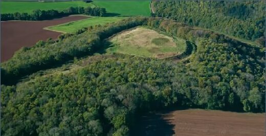
The Silures, a powerful and warlike tribe of Southeast Wales occupied the north shore of the Bristol Channel, in what is now known as Glamorgan and Monmouthshire. Their neighbours to the north were the Ordovices of Central Wales, while to the east lay the Dobunni.
The Silures name in Latin means 'the people of the rocks', reflecting to the mountainous region which they inhabited. The Silures were noted for their particularly dark complexions and black curly hair. On account of their appearance, the Roman historian Tacitus thought that they may have crossed over from Spain at an earlier date:-
"... the swarthy faces of the Silures, the curly quality, in general, of their hair, and the position of Spain opposite their shores, attest to the passage of Iberians in old days and the occupation by them of these districts."
The Silures were identical with the small, dark, long-headed Basque-speaking people found in the western Pyrenees, who were a fragment of the Iberians. Tacitus talks of the Silures' "natural ferocity "... but neither severity nor clemency converted the Silurian tribe, which continued the struggle and had to be repressed by the establishment of a legionary camp." Led by Caratacus, King of the Catuvellauni, they fought the Romans fiercely from about 48 AD. A Roman legionary fortress was established first at Glevum (Gloucester) and later at Isca (Caerleon), and by 78 the Silures were overcome by Sextus Julius Frontinus (73/74-77).
Although the most obvious physical remains of the Silures are hillforts such as those at the Silure capitol at Llanmelin and at Sudbrook, there is also archaeological evidence of roundhouses at Gwehelog, Thornwell (Chepstow) and in other locations, and evidence of lowland occupation exists at Goldcliff. The Romans forcibly transferred the inhabitants of Llanmelin about a mile to the south to a new town, established in the rectangular Roman pattern. Known as Venta Silurum (Caerwent, southwest of Chepstow, Monmouthshire). The settlement's massive Roman walls survive, and excavations have revealed a basilica, baths, and an amphitheatre.
The Trinovantes
The Trinovantes occupied the area now known as Essex. Their capital may have been at Colchester (Camulodunum). They used coins, cremated their dead, ate from plates and drank from cups. The Trinovantes were the first of the British Celtic tribes to be mentioned by a Roman author, appearing in Caesar's account of his invasion of 54 BC. By this date, they seem to have been already involved in a power struggle with the neighbouring tribes to the west who were to be forged into the kingdom of the Catuvellauni under Tasciovanus.
King Cunobelinus essentially absorbed the two tribes into one larger kingdom and he or his predecessors, established Colchester is a new royal site on the same model as St Albans. It was Colchester, that became the target for the Roman Emperor Claudius' invasion in AD43. After the Roman Conquest, the Trinovantes were restored as a tribal entity in the form of a civitas (an administrative unit or county) within the new Roman Province. The capital of the civitas was the Roman city of Colchester, which was originally founded as a colony for retired Roman soldiers.
The Brythonic Celtic People Previous Next Iron Age Hillforts
